Not only stopping at the 4 highest mountain peaks in the North, the highland nature of Vietnam always attracts tourists with landscapes of different beauty but somewhat dangerous. In this article, we will share with you about the 4 longest and most dangerous passes in North Vietnam.
Vietnam is famous for many beautiful scenes, from vast primeval forests, beautiful beaches to golden fields. But for those who love adventure travel, what they like most is to explore the high and dangerous mountains. Away from the noisy and bustling capital Hanoi, on long craggy passes, looking out into the distance is the surrounding green mountain nature. Continuing on that road, you will meet ethnic minority villages and have more opportunities to exchange and learn about their culture. So which are the top 4 highest and most dangerous passes in North Vietnam? Let's find out in the article below!
1. O QUY HO PASS
O Quy Ho Pass in Sapa is known as one of the four great peaks in the Northwest. Located at an altitude of up to 2000m above sea level, standing on O Quy Ho pass looking down is like seeing through the whole world. From here, visitors can see the Hoang Lien Son range hazy in the afternoon sun, or Fansipan peak engulfed in white mist. Not only has the breathtaking scenery, O Quy Ho pass also has extremely attractive ethnic Sapa dishes. Stopping at a small roadside shop, tourists can enjoy a lot of different special dishes.
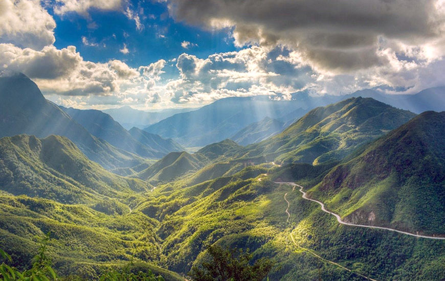
O Quy Ho Pass. Source: baoquangninh
2. MA PI LENG PASS
Ma Pi Leng Pass - "horse's nose bridge", known as the king of the passes in the Northwest mountains, is a rugged pass road about 20km long, in Meo Vac district and Ta Lung commune, Dong Van district.
Ma Pi Leng Pass is located at an altitude of 1,200m in the Dong Van Stone Plateau on the road named Hanh Phuc connecting Ha Giang city with Dong Van and Meo Vac districts. From the top of Ma Pi Leng, visitors can enjoy a panoramic view of Dong Van Karst Plateau. The majestic mountain scenery with one side is a steep cliff, the other side is the deep abyss of Nho Que river with jade green water. Visitors can come to Ma Pi Leng from January to March because this is the time of the flower seasons such as plum, peach, and mustard flowers. April is attractive with the Khau Vai love market, September is attractive with the ripe rice season on Hoang Su Phi or November and December are the season of buckwheat flowers.
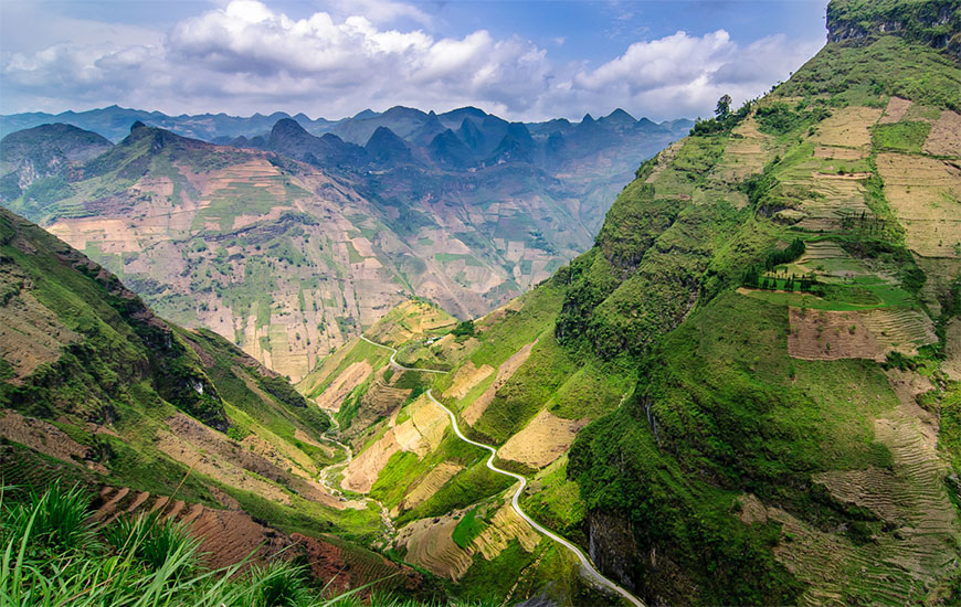
Ma Pi Leng Pass. Source : Collective3. KHAU PHA PASS
Located in the top four great peaks of the Northwest Pass,
Khau Pha Pass (Yen Bai) is also a name chosen by many backpackers as a destination to conquer their own limits. Khau Pha Pass is located on Highway 32, the bordering area between Van Chan and Mu Cang Chai districts of Yen Bai province. This pass is more than 30 km long, located at an altitude of 1,200 m above sea level and passes many famous landmarks. The reason why the pass is called Khau Pha is because the pass crosses the top of Khau Pha mountain - the highest mountain in Mu Cang Chai. Besides, in the local language, Khau Pha also means Horn of Heaven - the place of harmony between heaven and earth. Standing on the top of the pass, you can zoom out to see the entire Khau Pha valley area, in the distance are Lim Thai and Lim Mong villages.
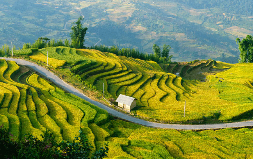
Khau Pha Pass. Source: Kim Phuong
4. PHA DIN PASS
Pha Din Pass, also known as Pha Din Doc, is the place connecting the border of two provinces of
Son La and Dien Bien. With a length of 32 km, this pass is located on National Highway 6. It is part of Phong Lai commune, Thuan Chau (Son La) district and another part of Toa Tinh commune, Tuan Giao (Dien Bien) district. The name Pha Din pass is originally from the Thai language, Pha Din, in which Pha means "heaven", Din means "earth", meaning this place is the confluence between heaven and earth. also the name implies the danger of this pass.
Pha Din Pass is impressive because its position is very dangerous and precarious, one side is a cliff and the other is a deep abyss. Halfway through Pha Din pass is often cloudy, and at the foot of the pass are scattered villages. Standing on the slope of the pass in Dien Bien province, looking down, visitors will see the Muong Quai valley spreading with green hills and mountains, looming the first villages of Tuan Giao district. However, when approaching the top of the pass, almost no village can be seen but only the deep blue sky and majestic mountains and forests blend into one.
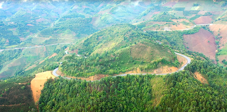
Pha Din Pass. Source: BDS.net
Vietnam is a charming country, there is no shortage of beautiful scenery with friendly Vietnamese people. To experience all of these passes, you should plan ahead and prepare carefully, even practice necessary skills such as motorbike driving, climbing, survival skills.
Written by Chung Nguyen, Hao Pham - Assistant Manager for Mr Linh’s Adventures.